Difference between revisions of "Land and Water Forms"
From wikisori
m (1 revision) |
|||
| Line 1: | Line 1: | ||
| − | + | [[Image:Land and Water forms 1.jpg|center]] | |
=== Age === | === Age === | ||
Revision as of 01:09, 9 August 2010
Contents
Age
3-6
Materials
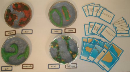
Models representing the following forms of physical geography:
- Lake
- Gulf
- Bay
- Island
- Peninsula
- Cape
- Isthmus
- Strait
Water jug
Sponge
tray
A set of Terminology cards of maps of the Land and Water Forms including definitions of particular land or water form.
Preparation
This can be an individual or group presentation.
Presentation
Directress pours water into one of the forms, saying, "Look, I've made a Lake. A Lake is water surrounded by land. Would you like to make a lake?"
She pours the water back into the jug and allows the child to repeat the exercise.
Repeat for the Island.
Introduce the landform in pairs.
Control Of Error
Points Of Interest
Land and Water form definitions:
- A Lake is surrounded by land.
- An Island is land surrounded by water.
- A Bay is a sea, partly enclosed by land.
- A Cape is land protruding out into the sea.
- A Gulf is sea penetrating a long way into the land.
- A Peninsula is a land jutting out into the sea.
- A strait is a narrow strip of water joining two large areas of water.
- An Isthmus is a narrow strip of land joining two large areas of land.
Purpose
- Introduction to Land and Water forms.
- Make the child aware of the existence of this forms.
- Preparation of later systematic study of physical geography.
- Refine eye-hand coordination.
Variation
Handouts/Attachments
